Al-Juhfah: The Miqat That Became a Ruin
Short answer
Al-Juhfah is one of the five miqats designated by the Prophet, for pilgrims from the Levant, Egypt, the Maghrib and Africa. It lies about 178 kilometres from Makkah on the road from Madinah. It was originally called Mahya'ah and is now an archaeological site, with pilgrims using Rabigh, about 17 kilometres away, instead.
Key takeaways
- ✓Al-Juhfah is the miqat the Prophet named for the Levant, Egypt, the Maghrib and Africa.
- ✓It lies about 178 km from Makkah, on the route from Madinah.
- ✓Its original name was Mahya'ah. It was renamed after a flood swept away its people.
- ✓The Prophet stopped there during the Hijrah with Abu Bakr.
- ✓His last visit was in 632, travelling to the Farewell Pilgrimage.
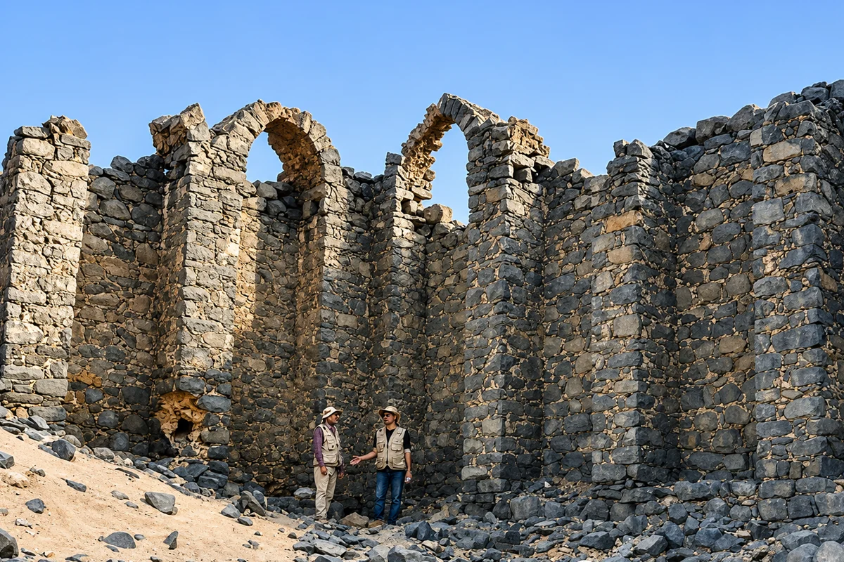
- ✓Archaeology has revealed a walled city of black basalt with a fortress and water systems.
- ✓In practice it has been replaced by the miqat at Rabigh, about 17 km away.
Quick facts
- Where
- About 178 km from Makkah
- Original name
- Mahya'ah
- Serves
- The Levant, Egypt, the Maghrib, Africa
- Designated by
- The Prophet, one of the five
- Present state
- Archaeological site
- Used instead
- Rabigh, about 17 km away
- Building material found
- Black basalt
- Part of Umrah?
- Only as a point of ihram
One of the five
Al-Juhfah is one of the five boundary points the Prophet designated for entering ihram. It serves pilgrims from the Levant, Egypt, the Maghrib, and Africa, and anyone else whose route passes it.
Saudipedia places it about 178 kilometres from Makkah, on the route between Madinah and Makkah, north-west of Makkah and south-east of Rabigh Governorate.
It is also the only one of the five that has effectively stopped being used, which is what makes it worth a proper page rather than a line in a table.
The flood in its name
The village was originally called Mahya'ah.
Saudipedia records that it came to be called al-Juhfah because a flood swept through it one year and carried away its inhabitants. The root of the word carries that sense of being swept off.
That is an unusual thing for a place name to record, and it tells you something about the country. These are dry valleys that flood violently and rarely, and settlements on them live with that.
What was actually there
Not a marker in the desert. A town.
Saudipedia describes al-Juhfah as one of the stations on the route between Madinah and Makkah, and records that the sources mention a pool and many wells, homes and a market. At the entrance of the village stood a mosque attributed to the Prophet.
Archaeological work at the site has gone further, and the findings are worth setting out because they change the picture:
- The remains of an expansive walled Islamic city.
- Buildings of black basalt stone, built precisely and solidly, with massive thick high walls coated in layers of clay and plaster.
- Structural fortifications, including stone walls and a large fortress, built to defend residents and pilgrims.
- Two water systems. A medium-sized circular pool built of black basalt, and an underground canal, a large-scale project with many vertical wells extending over long distances until the water surfaced to irrigate the low ground.
An underground canal with vertical shafts is serious engineering. Somebody invested heavily in making this a place where large numbers of travellers could stop, drink and be safe.
The Prophet at al-Juhfah
Saudipedia records that he visited al-Juhfah several times.
He stopped there with Abu Bakr during the migration from Makkah to Madinah, which places it on the Hijrah route.
His last visit was in 632, on the way to the Farewell Pilgrimage, when he stopped there with thousands of companions and prayed.
That is a striking pair of visits to hold together. The same stretch of ground saw him pass as a hunted man with one companion, and again a decade later at the head of the largest gathering of his life.
Why pilgrims use Rabigh instead
The practical situation today is simple. Al-Juhfah has been replaced by the miqat at Rabigh, about 17 kilometres away.
The reason is that al-Juhfah is a ruin. There is no town, no facilities and no infrastructure for the number of pilgrims who need to enter ihram on that road. Rabigh is a functioning town on the modern highway with a mosque built for the purpose.
Is entering ihram at Rabigh valid? Yes. It lies on the same line, slightly ahead of al-Juhfah for someone travelling towards Makkah, and it is the recognised point in practice. Scholars have long accepted entering ihram at a point aligned with a named miqat when the named site itself is not usable.
So nobody needs to search the desert for a ruined village to start their Umrah correctly.
Who this miqat is for
Anyone whose route to Makkah passes it. Historically that meant pilgrims from Syria, Palestine, Egypt, North Africa and further into Africa, arriving overland or by sea and joining the road from the north.
Today, in practice, it applies to anyone travelling by road from Madinah or from the north-west towards Makkah.
The miqat belongs to the road, not to nationality. An Egyptian pilgrim who flies into Jeddah does not use al-Juhfah. A Malaysian pilgrim driving down from Madinah does.
Our Qarn al-Manazil page sets out the full table of the five miqats and who each serves.
Visiting the site
This is for people interested in the archaeology and the history, not for anyone who needs to enter ihram.
- It is an archaeological site. Treat it as one: do not climb on walls or remove anything.
- Access can be restricted. Excavated sites in Saudi Arabia are often fenced, and permission arrangements change.
- There is no visitor centre and, as far as we could establish, no interpretation on site.
- Rabigh is the nearest town with anything, at about 17 kilometres.
- Combine it with the road stops: Usfan and al-Abwa.
Our Makkah to Madinah private car covers that road and can stop, and the transport guide compares it with the train. Fares reviewed August 2026.
Accuracy note
That al-Juhfah is one of the five mawaqit designated by the Prophet, serving the people of the Levant, Egypt, the Maghrib and Africa, is established in the authentic collections and is set out by Saudipedia in the same terms.
Its location about 178 kilometres from Makkah, its original name Mahya'ah, the account that it was renamed al-Juhfah after a flood carried away its inhabitants, the mention in the sources of a pool, many wells, homes and a market, and the mosque attributed to the Prophet at the entrance of the village all come from Saudipedia.
The archaeological findings described, an expansive walled Islamic city with black basalt buildings, thick high walls coated in clay and plaster, structural fortifications including a large fortress, a circular basalt pool and an underground canal with many vertical wells, are as reported by Saudipedia from studies conducted at the site.
That the Prophet visited al-Juhfah several times, stopped there with Abu Bakr during the migration, and made his last visit in 632 on the way to the Farewell Pilgrimage where he stopped with thousands of companions and prayed, is likewise recorded by Saudipedia.
That al-Juhfah has been replaced in practice by a miqat at Rabigh about 17 kilometres away is recorded by Saudipedia. Access to the archaeological site may be restricted. Fares are our own published rates, reviewed August 2026. Verified August 2026.
Frequently asked questions
Planning a Saudi trip?
Pre-book a private car, find a stay, or ask us anything on WhatsApp.
Last updated: 27 August 2026·Sources reviewed by the Wadana Go editorial team.